Introducing Street Types for London, a new way of mapping London’s roads. Over the last 18 months more than 400 transport professionals collaborated to examine how the road network is helping people move across the Capital but also providing liveable social space.
In 2012, the Mayor of London set up the Roads Task Force to consider how to tackle the challenges facing London's roads. It recommended that London's 34 traffic authorities use a new 'street family' as a practical way to understand the mixed use of our roads.
Five pilot studies tested different ways of categorising streets before work began using the chosen method in September 2014.
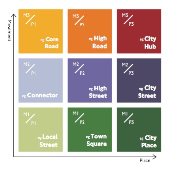
The process uses a series of workshops to consider the 'movement' and 'place' functions of each road separately. These are then combined and each road is classified according to nine street types and represented on a final map.
Instead of describing the quality of a road, the final map illustrates common agreement on its current function. The map also helps decision makers understand the amount of change needed when planning for the future and can be refined as roads evolve and new data emerges.
Read more about the Street Types for London project at https://tfl.gov.uk/street-types